Showing posts with label Newfoundland. Show all posts

Saturday, July 23, 2016

The Whales Are Back!

Diving whales
Each year along the shores of Newfoundland and Labrador, humpback whale sightings are few and far Mallotus villosus) is a vital part of the food web here, and it's responsible for nourishing not just the whales but the area's substantial seabird population, whose breeding season is timed to coincide with the caplin's spawning time. When the caplin arrive in their billions, so do the whales, intent on taking on close to a third of their body weight during the summer feeding season. When they're feeding, they concentrate completely on the task at hand until their principal food source arrives: the caplin (or capelin,


Humpback tail
On a recent trip out of Bay Bulls with Captain Wayne's Marine Excursions we spotted whales in just a few kilometres away from the shore -- a group that were actively feeding. We headed a little closer and stopped for a look. The whales were headed our way, staying at the surface briefly then diving to feed at depth. Several would surface at once, then dive within a few seconds of one another. As a result, there were ample opportunities for great ID shots of the tails' distinctive undersides. (See One Fluke at a Time, a post about humpback identification.)

Caplin after spawning
We spent nearly two hours observing at a respectful distance, on a near-perfect July day. When they neared the surface, the whales' white pectoral fins showed up, appearing green through the sea water. Proprietor Wayne Maloney's uncanny whale sense came through as always, and we were treated to a truly unforgettable experience.Here are a handful of images from our visit. What a day on the water!


Thursday, March 24, 2016

St. Anthony -- In the Footsteps of Grenfell

St. Anthony Sunrise
Travel down the Great Northern Peninsula (yes, north is "down" here) and you'll find yourself in St. Anthony, the outpost at the end of the road. To be truthful, the road has only been here for sixty years or so; like many small towns around the coast of Newfoundland, this port was once served only by water, as a stop on the coastal boats that plied the island's shores. This community of roughly 2500 people serves as a supply centre for the surrounding area, so there are grocery stores, hotels, restaurants and many other services, but it's St. Anthony's history that makes it remarkable.


Sun Porch, Grenfell House
In 1892, a young and determined doctor arrived here from England; this was then an English colony, and the Royal National Mission to Deep Sea Fishermen carried out visits to bring medical care to the people of northern Newfoundland and the Labrador coast, and Dr. Wilfred Grenfell was here to do what he could for his fellow man. He was ahead of his time in realizing that social conditions, nutrition and physical activity were all part of overall health, and he went on to form an organization to raise funds to provide health services in the region. His legacy lives on the present-day health care system serving St. Anthony and the remote coastal communities of Labrador. The International Grenfell Association's headquarters were in St. Anthony and it was here that Grenfell made his home. One of my own favourite aspects of his house is the warm and welcoming sun room that wraps around it.


The View from Tea House Hill
Today, the Grenfell Historic Properties provide an opportunity to learn about this remarkable man through the Grenfell Interpretation Centre, the restored house, and the Tea House Hill Trail which provides wonderful views of the surrounding area. From the Grenfell Dock, Northland Discovery Boat Tours provide whale-watching and iceberg-viewing opportunities with expert interpretation. This area boasts one of the longest iceberg seasons in Newfoundland and Labrador, as well as frequent sightings of humpback whales and dolphins and even occasional pods of killer whales!

Iceberg Near St. Anthony
St. Anthony's harbour is a busy one, with a fleet of fishing boats, processing plants, and a large wharf that accommodates vessels carrying freight. Several times a summer, small expedition cruise ships visit to take in the sights in the area.


Tuesday, March 15, 2016

Walking on the Moon -- Newfoundland's Tablelands

Last winter's snow
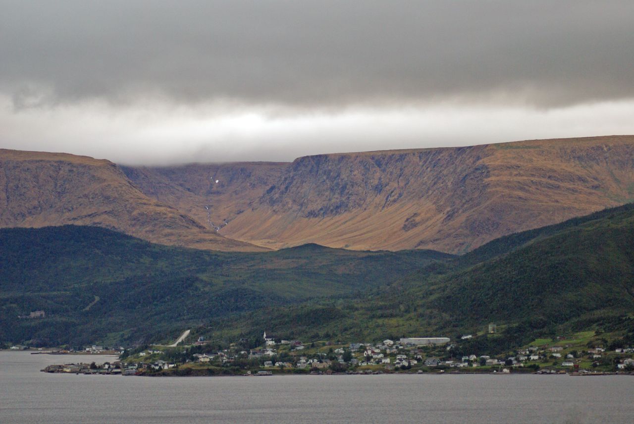
Gros Morne National Park is a wonderland for geologists and hikers alike. One of its best-known features is a range of flat-topped hills beside Route 431 just outside the town of Woody Point -- a spot known as the Tablelands. The rusty orange tone of the hills comes from the peridotite that is their main component; when it's freshly exposed, this rock is a dark grey-green, but with oxidation it takes on a mellow golden tone. This rock is part of an exposed section of the earth's mantle; further metamorphic activity turns it into a rock called serpentinite, examples of which can be widely found here.


Gros Morne's Tablelands
Earth's mantle? That's right -- this is a section of rock that was once deep below the earth's surface, formed roughly 1.2 billion years ago. The process of continental drift several hundred million years ago forced this mantle rock upward, and subsequent erosion has given the hills their present form. They remain barren because the peridotite is low in life-sustaining nutrients and contains toxic concentrations of heavy metals. What vegetation that is found here is mostly along an old roadbed, on rock that was brought in for the purpose of road building. A well-maintained trail follows this roadbed, crossing Winterhouse Brook, which flows out into Bonne Bay just outside Woody Point.

Round-leaved sundew (Drosera rotundifolia)
A walk along this trail reveals a surprising number of small, hardy plants that have developed the survival tactics necessary for such a forbidding environment. Many of them, like pitcher plants, butterwart, and the round-leafed sundew shown at left are insectivorous; instead of obtaining all their nutrients from the soil, they attract insects and through a variety of processes absorb the life-giving substances they need from the insects themselves or from their droppings. It's not an easy life, to say the least.


Winterhouse Brook
Continue along the trail as far as Winterhouse Brook (right), where snowmelt and run-off from the tops of the Tablelands form a swift-running stream. This area has a challenging winter climate, and a heavy snow load on the upper slopes often persists into late summer. If you think this place looks strange and otherworldly you're not alone. In fact, the landscape here is so forbidding that NASA has sent research teams here to investigate the area's similarity to the surface of Mars. On a beautiful summer day, though, it's a beautiful and fascinating little corner of Earth, and well worth a side trip. Woody Point is located on Newfoundland and Labrador Route 431, about 70 km from the town of Deer Lake. It has a motel, bed and breakfast accommodations and campgrounds nearby, and there are shops, restaurants and other services, and is roughly an hour away from Rocky Harbour. Parks Canada's Discovery Centre has high-quality informative displays, park information and a gift shop.

Woody Point and the Tablelands

Wednesday, March 09, 2016

Exploring Rose Blanche

Rose Blanche Lighthouse
When approaching Rose Blanche, the most striking feature on the landscape is an impressive stone lighthouse, one of a series built between 1871 and 1873 along this coast. The Rose Blanche light is one of the last surviving stone lighthouses on the Atlantic Coast of Canada, and had fallen into disrepair by the 1990s, but the stone steps inside the tower were of such robust construction that they kept the building from falling down; restoration of the building was completed in 1999.

The Harbour at Rose Blanche

The little harbour of Rose Blanche is now accessible by road, but is still well off the beaten path so it sees fewer visitors than many more accessible Newfoundland communities. My own first visit here was on a superb July morning in 2015, on a cruise with  Adventure Canada. We dropped anchor just outside the harbour and made our way to shore in Zodiacs, landing at the public wharf and hiking to the lighthouse. The old path led around the inner harbour and over the hills, where the sun warmed berry fields and small ponds along the way. After seeing the lighthouse and the well-designed interpretation area at the end of the road, there was a warm welcome for the ship's passengers at St. Michael and All Angels Anglican Church on the hill overlooking the harbour.


Lighthouse Point
Looking seaward
Rose Blanche now shares government with neighbouring Harbour Le Cou, the subject of a well-known traditional song from Newfoundland, here performed by the group Ryan's Fancy. If you're visiting by road, the community is located on Newfoundland's scenic southwest coast, about 45 minutes east of Port aux Basques via provincial Route 470.


Lighthouse interior


Take a walk through Rose Blanche via Google Street View here. Amenities include bed and breakfast accommodations, shops and cafes.

Wednesday, March 02, 2016

Life on the Rocks in Point Riche

Marine gastropod fossil
One of my favourite moments during a visit to western Newfoundland is the "life on the rocks" exploration of Point Riche. The headland lies near the town of Port-au-Choix, on the island's Great Northern Peninsula, and its white octagonal lighthouse with a bright red lantern room is a striking sight. Below the lighthouse, though, is where this spot's treasures are found. In the broad limestone beds on the shore, thousands of marine fossils, mostly cephalopods and gastropods can be seen.  It takes only a moment for the eye to become accustomed to the search; when it has, a scan of the rocks reveals one tight spiral after another, sometimes dozens within a space the size of a small notebook.

Fossils at Point Riche
Among the fossils are tidal pools that evaporate quickly in the summer sun, leaving a rim of salt around their edges. In the cracks of the rock, tiny plants take root in the most challenging of circumstances. Minke whales, seals and dolphins can occasionally be seen passing by, and when there are small fish like capelin or juvenile herring in the area, northern gannets knife into the water. There is a small herd of caribou living in the area, and a few moose can also be seen from time to time.

The limestone barrens on the Northern Peninsula are home to many varieties of calcium-loving plants, some of them found only in this environment, so it's necessary to tread carefully on the plateau above the shore. Just up the road, also part of the Port-au-Choix National Historic Site, is an interpretation centre that concentrates on the area's remarkable human history; a succession of occupations of the area by various cultures go back some 6000 years.

The nearby towns of Port au Choix and Port Saunders are centres for fishing in the area, and there are restaurants, hotels and other services nearby.


A miniature garden among the rocks


Wednesday, March 06, 2013

The Horses of Cape Bonavista


Until relatively recently, common grazing ground was found in most of the small communities of Newfoundland and Labrador. Horses and ponies, sheep, goats in in some cases cattle all grazed on community pastureland, ranging at will. If fences were constructed, they served not to keep animals in, but to keep them out of the immediate areas around the houses or vegetable gardens. Today, with less reliance on family farms and fewer people following a traditional rural lifestyle, that community pastureland is fast disappearing. There are a handful of communities, about thirty, where the practice continues and Bonavista is one of them. The community pasture is located on a small peninsula or cape, and a public road leading to the Dungeon Provincial Park runs through the middle of it. The area is fenced, and at the points where the road goes through these fences, cattle grids have been installed. Cattle, sheep and horses all graze here: the curious horses sometimes approaching people who stop for a photo -- like these three.

Monday, March 04, 2013

Iceberg Season Drifts Into View

April, May and June are prime iceberg-watching season in Newfoundland and Labrador,since this is the time of year when these northern giants drift south on the Labrador current after spending the winter frozen into the sea ice.  They'll gradually break free as the ice begins to break up, and move with the current to the shores of Labrador and then the island of Newfoundland. Their pace is slow and stately, befitting to the offspring of glaciers, and like most youngsters they move much more quickly than their parents. They move at the speed of the current, getting the occasional boost from favourable breezes if the berg is tall enough to act as a sail. They come in all shapes and sizes, from growlers the size of a cottage to massive,
floating islands of ice like those that calved from Greenland's Petermann Glacier in 2010 and 2012. They heave into view in the distance and inch to the south each day, but changes in wind direction can play tricks: one berg that had grounded on the south side of Bay Bulls (near St. John's) last spring suddenly freed itself drifted out of sight to the north before abruptly changing direction and moving south, ending up in Ferryland by the next morning. Bergs are often at their most spectacular as they begin to break up; the centre of gravity shifts as a result of erosion from sun, wind and water, and suddenly the massive weight of the berg can no longer support itself and a huge section will crack off, or the entire berg will roll and chunks of ice will fly in arcs to the water. It's important to treat these ice giants with respect, but they can certainly provide some wonderful viewing opportunities.

Monday, October 22, 2012

Branch and the Cliffhouse

I always look forward to visiting Branch, a picturesque community nestled on the shores of Newfoundland's St. Mary's Bay. The setting for this village of approximately 300 is striking: a river flows through pasture land where horses, sheep and cattle graze. Colourful fishing boats line the apron of the small, sheltered harbour. Scattered farms draw the eye upward to the surrounding hills, and waves crash in on a broad, curving beach front. Overlooking it all, from a vantage point high on a cliff, is a charming bed and breakfast, the Cliffhouse at Red Point.
What a setting! The inn is perfectly situated to enjoy sweeping views of the village, the Wester Cove, and Hayjer's Rock, whose name seems to be a corruption of "Hare's Ears". The Cliffhouse was purpose-built as a bed and breakfast, and its three well-appointed guest rooms have comfortable beds and private four-piece baths stocked with lots of thirsty towels. The amenities and the view would provide ample reasons to stay here, but the true treasures at the Cliffhouse are its hosts, Chris and Priscilla Mooney. Priscilla is the mayor of Branch, and its staunchest supporter.
She works tirelessly to further the interests of its residents, and is a vocal advocate for the area's culture and traditions. Her husband Chris is a naturalist interpreter at Cape St. Mary's Ecological Reserve, a few miles away. Thanks to them, the Cliffhouse at Red Point provides an opportunity for not only accommodations and a hearty breakfast but great conversation that explores Branch's rich heritage and folklife, making a stay in this intriguing place even more memorable.


Tuesday, October 16, 2012

Autumn in the Bay of Islands

Autumn in the Bay of Islands on Newfoundland's west coast is one of Atlantic Canada's best-kept secrets. Dramatically sculpted hills are covered with mixed forests that provide some of this region's finest displays of fall foliage, and the city of Corner Brook provides a scenic focal point for all this splendid color. The Humber River was named by Captain James Cook during his hydrographic survey expedition to the area in 1767. In 2012, a statue of Cook by renowned sculptor Luben Boykov was unveiled; it can be seen on a hilltop overlooking
Corner Brook and the Humber Arm. Cook spent several years charting the coasts of Newfoundland, beginning in 1762; his stay in the Bay of Islands region marked the final year prior to his voyage to Tahiti. The broad, sheltered waterway he mapped is lined on both north and south sides by a series of small communities that boast impressive views of Guernsey, Tweed and Pearl Islands in the distance or of Corner Brook itself. A short drive along the south side of the bay leads to York Harbour and Lark Harbour, while a similar trip along the north side leads through Irishtown and Summerside, ending at beautiful Cox's Cove (seen below) where in summer, True North Charters provides a boat tour that explores the nearby coastline, including the striking headland known as Penguin Head.


The Corner Brook area also boasts a network of walking trails that is well-used by local residents; the sections that lead alongside the Corner Brook Stream are particularly attractive during foliage season. A short drive to the north is
Marble Mountain, Newfoundland's best-known ski hill, where the autumn color of the surrounding valleys is reflectedin the pools and rills of the Humber. This region of Newfoundland's west coast is beautiful at any time of year, but the brightly painted hills of fall make it well worth an extended visit.

Tuesday, August 14, 2012

A Morning With the Seabirds

You'd definitely have to call it a busman's holiday: on the day following my last Newfoundland Adventure of the 2012 season, I drove to Bay Bulls for a trip with friends. We headed for Captain Wayne's Marine Excursions and boarded the Blackfish 1 for a visit to the Witless Bay Ecological Reserve and a look at the surrounding coastline. After a loop through Island Cove, a look at the sea stacks of Spoon Cove, and a visit to a beautiful sea cave, we struck out for Gull Island, nesting site for thousands of Atlantic puffins, kittiwakes, murres and storm petrels. Light fog was hanging over the area and sea conditions were excellent, with an ocean so calm that the hundreds of birds in the water cast perfect reflections. We travelled slowly alongside Gull Island, pausing to photograph the puffins outside their burrows on the grassy slopes and lounging on the rocks near the water's edge. These photogenic little birds seemed to be in a particularly cooperative mood, posing for us as we slipped past. Although the fledging season is here and many pufflings have already left their burrows, there were still plenty of adults to be seen. There were also many common murres, some
guarding chicks that had not yet fledged. The young birds are ready to leave the nest at about three weeks of age;; unable to fly, they tumble or glide down the cliffs to the water below. Once the chick has fledged, the male parent attends it closely for up two two months as the birds venture out to the open sea. Within about two weeks the young are able to fly. The female stays at the nesting site for an average of two weeks or slightly more. This is the time of year when the
dense concentration of murres on the island begins to thin out.

A little farther south on the island, an unusual sight awaited us: one of this year's black-legged kittiwake chicks exhibited a condition called isabellism, a dilution of melanin, the pigment that colours the bird's black feathers and legs. In isabellan birds, one of the two types of melanin, Eumelanin and Phaeomelanin, is missing, resulting in a bird that shows a pale tan colouration
in areas that are normally dark.

As we reached the southern end of Gull Island and headed for open water, we found that the fog and onshore wind had brought a large number of greater shearwaters, birds that are usually found far at sea. These birds nest in Tristan da Cunha, a remote group of volcanic islands in the South Atlantic. One of these curious birds swam up to the boat to investigate us, providing a great opportunity for a close-up shot. From our shearwater encounter, we headed north to view the area's beautiful coastline; more about that in a later post.

Sunday, June 10, 2012

It's Not What You See, It's How You See It.

There's an old adage that states "It's not what you say, it's how you say it." In other words, the gist of the statement is important, but the phrasing is what shapes the final interpretation. When it comes to visiting some of the planet's most important natural areas, though, it's not what you see, it's definitely how you see it. There are wondrous sights to be observed, but observation must be coupled with caution and respect to avoid unnecessary stress to wild populations; this is an occasion when a
long lens is extremely useful for capturing bird or animal behavior. On a visit to the Witless Bay Ecologial Reserve, North America's largest Atlantic puffin (Fratercula arctica) breeding site, for example, pair behaviors like billing (the touching and rubbing of bills) bill tossing (rapid upward movements of the head showing the underside of the bill) and wing flapping displays can be seen. While it is possible to go ashore on the island, human intrusion is limited to legitimate research purposes; however, boat trips from the nearby communities of Witless Bay and Bay Bulls offer
excellent opportunities for puffin observation. The best views, though, come by way of a measured and careful approach that is quiet and unobtrusive. Boat access to the islands of the reserve is limited; tour boat operators require a permit issued by Newfoundland and Labrador's Department of Environment and Conservation, Parks and Natural Areas Division. It's a wonderful place to visit, and thanks to protection and limited access it will be here not only for us but for future generations.

Wednesday, May 23, 2012

For the Love of Whales

Wayne Maloney of Bay Bulls, NL is an admitted whale-aholic -- at least that's how he puts it. He's addicted to the big cetaceans that make their way to the shores of Newfoundland and Labrador every summer to feed. Wayne's been operating the boats that go out whale watching from Bay Bulls for close to thirty years. He's the son of boatbuilder Gene Maloney, so when he found himself in a position to start a whale watching
business of his own, the question of where he'd get a suitable boat wasn't difficult: he'd build it. And build it he did -- from the keel up, and from a design that incorporated a "wish list" that was many years in the making. Countless hours were spent poring over plans to get the lines just right, and the details of the deck layout complete. Theatre seating would allow for excellent forward-facing viewing, and the aft cockpit would mean uninterrupted sightlines for those on board. The shot above shows this beautiful boat, christened
Blackfish 1, in progress. He'd be the first to tell you he didn't do it all himself; he's quick to give credit to the good friends who lent a hand, a strong back, or a heaping helping of moral support. Their assistance just helped to spur on the inevitable, though, since this is a man who was born to the water and who has what seems to be uncanny whale sense. He's studied humpbacks and their habits for years, and it's paid off in a knowledge of whale psychology that's remarkable to see in action. It's all based on a deep-seated respect for the whales, and for observing their interaction without intrusion. In addition to the humpbacks that arrive in the area in midsummer, there are minkes, fin whales, dolphins, occasional visiting pods of orcas on the hunt, countless seabirds to be seen on the islands of the Witless Bay Ecological Reserve and miles of spectacular coastal scenery. Wayne and Blackfish 1 are now in business as Captain Wayne's Marine Excursions, and can be found on the Northside Road in Bay Bulls, NL.

Wednesday, April 18, 2012

Icebergs and Sun Pillars

On Monday evening a friend called to say that there were a couple of icebergs grounded just outside the "gut" at Quidi Vidi, a small village that's part of St. John's. Would I like to go take a look? I didn't have to be asked twice -- I love the icebergs that work their way south along the Labrador current in spring and early summer, and I wasn't about to pass up an opportunity to see and photograph one, especially in a setting as picturesque as Quidi Vidi. We drove to a point above the village, then walked to the Quidi Vidi Battery, not yet open for the season. The hill gave a commanding view of the bergs in the narrow opening to the small harbour; the two bergs were of completely different
shapes, one flat or tabular and the other pinnacled and looking a bit like a huge white walrus. There were thirty or so people gathered on the point, taking photos or just enjoying the view, but the light was fading fast. We decided to return the following morning to see the bergs in the early light. Serendipity provided the perfect weather conditions for a sun pillar as the day dawned, making for a spectacular scene that was well worth the early start. When an opportunity arose for yet another visit to the bergs that evening, of course I couldn't resist. After a walk to the end of the Barrows Road and a scramble across the rocks, another friend and I joined the watchers on the point and settled in to
enjoy the view and the changing light. We were delighted to see a couple of colourful kayaks head out for an evening paddle, past the bergs and along the coast. While they were gone, the tabular berg shifted on the tide and nearly closed off the opening to the harbour; fortunately there was enough room for them to get past, but the return trip was definitely a bit more challenging than the outbound one. Thanks to those two kayakers for adding extra interest to this beautiful evening!

There is a website that provides location data and background information on icebergs in Newfoundland and Labrador -- www.icebergfinder.com operates during iceberg season and gets its data from both satellite and local observer information.