Showing posts with label Newfoundland and Labrador. Show all posts

Saturday, July 23, 2016

The Whales Are Back!

Diving whales
Each year along the shores of Newfoundland and Labrador, humpback whale sightings are few and far Mallotus villosus) is a vital part of the food web here, and it's responsible for nourishing not just the whales but the area's substantial seabird population, whose breeding season is timed to coincide with the caplin's spawning time. When the caplin arrive in their billions, so do the whales, intent on taking on close to a third of their body weight during the summer feeding season. When they're feeding, they concentrate completely on the task at hand until their principal food source arrives: the caplin (or capelin,


Humpback tail
On a recent trip out of Bay Bulls with Captain Wayne's Marine Excursions we spotted whales in just a few kilometres away from the shore -- a group that were actively feeding. We headed a little closer and stopped for a look. The whales were headed our way, staying at the surface briefly then diving to feed at depth. Several would surface at once, then dive within a few seconds of one another. As a result, there were ample opportunities for great ID shots of the tails' distinctive undersides. (See One Fluke at a Time, a post about humpback identification.)

Caplin after spawning
We spent nearly two hours observing at a respectful distance, on a near-perfect July day. When they neared the surface, the whales' white pectoral fins showed up, appearing green through the sea water. Proprietor Wayne Maloney's uncanny whale sense came through as always, and we were treated to a truly unforgettable experience.Here are a handful of images from our visit. What a day on the water!


Tuesday, July 05, 2016

It's a great year for icebergs!

Waterline of Bay Bulls iceberg
The past few years have been exceptional for iceberg watchers. Hundreds of bergs have made their way down the Labrador Current, drifting south along the coast of Newfoundland and Labrador. 2016, in particular, has seen an unusually high number of tabular, or flat, icebergs. This isn't actually good news, since it means that increased numbers of icebergs are calving from Greenland's glaciers, but it's brought some impressive viewing for those who are willing to travel for a look at the results. On a mid-June visit to Bay Bulls and the islands of the Witless Bay Ecological Reserve with Gatherall's Puffin and Whale Watch, we were treated to some beautiful views of a small berg grounded along the south side of the bay. Although it was overcast, enough sun broke through the clouds to create a beautiful shade of blue near the berg's waterline.


An impressive pinnacle berg near St. Anthony
Finding that June iceberg while exploring the Avalon Peninsula was serendipity; however, near St. Anthony there's a good chance of seeing bergs in July and sometimes even into August. A trip with Northland Discovery Boat Tours is the perfect -- and safe -- way of getting a closer look. On a late June trip we encountered two bergs, one sharply sculpted and the other tabular. There were several others in the distance, including a huge tabular berg that appeared to be close to a kilometre in length. If you're lucky, they'll even manage to net a bit of broken ice from one of the bergs and provide a taste of ice that's over 10,000 years old; it's compacted snow from long before Earth's industrial age, so it's about as pure as it gets!

Pinnacle berg coming into view

Large tabular berg


There's still plenty of time to view icebergs in 2016 -- for the latest in sightings, visit www.icebergfinder.com

Tuesday, May 17, 2016

It's puffin time again!

Puffin on Gull Island, Witless Bay
It's that time of year again -- the puffins and other seabirds have returned to their colonies around the coasts of Atlantic Canada and Maine. There are many places around the region to see these small, sturdy birds, but two locations stand out: the Witless Bay Ecological Reserve for sheer numbers, and the Puffin Island at Elliston for land-based observation.


The Witless Bay Ecological Reserve lies south of St. John's, Newfoundland and Labrador. Witless Bay takes its name from an early family of settlers, the Whittles family; over the years the name has been corrupted to its present form. The four islands of the reserve lie just off the shore, from north to south they are Gull Island, Green Island, Great Island, and the fancifully named Peepee Island, whose name is said to be from the distinctive aroma that wafts from it in summer.


Typical "puffin weather" at Elliston
There are boat tours that allow for a closer approach to the islands; to protect the bird life, only those operators granted special permits are allowed to travel through the reserve. Bay Bulls is the primary starting point for these excursions, while operators can also be found in the town of Witless Bay and in Mobile, just to the south. All Witless Bay photos in this post are thanks to Captain Wayne's Marine Excursions of Bay Bulls. Other operators can be found here.


Puffins are true pelagics: they land on these rocky islands solely to mate and rear their young, spending the remainder of the year on the open sea. They burrow into the dirt of the island, or on rockier sites use narrow clefts in the rock for burrows. The pairs bond for life, returning to the same burrow year after year, although "divorces" are said to occur if one mate is a less-than-stellar provider. They're not the only seabirds that nest in the Reserve; there are also black-legged kittiwakes, common and thick-billed murres, black guillemots, and huge numbers of Leach's storm petrels among others.


Burrow entrance
Elliston, located on the Bonavista Peninsula, is the self-styled Root Cellar Capital of North America due to the large number of these storage structures that can be found there. Just outside the community is a headland accessed by a rocky trail that leads to a viewing point overlooking a small island that houses a breeding colony of puffins. The unusual thing about this spot is that when the weather and wind are right (often damp weather and a southeast wind) the puffins will land near the viewing area on the headland itself. This makes for some incredible up-close viewing experiences.

The puffins will be around until late August, with a few lingering into September, so there's plenty of opportunity for a good look during the summer months. Happy viewing!

Monday, April 18, 2016

The Birds of the Open Sea

Newfoundland and Labrador is a prime location to see birds that normally make their home on the open sea -- the pelagics. The word is defined as "of or relating to the open sea" and in birding it refers to those species that spend most of the year on the open water and make their way to land only for the breeding season and to rear their young. They're fascinating, hardy birds and there are many varieties of them. Here are a few that can be found along the coastline of Canada's easternmost province:


Atlantic puffin
Atlantic Puffin (Fratercula arctica)
Nicknamed the Clown of the Sea or the Sea Parrot, this member of the alcid family can be found in huge numbers around Newfoundland and Labrador. Not satisfied to host the largest colony of this seabird in North America, the province also boast the next five largest colonies as well! Puffins aren't great fliers, and are far more comfortable in the water than in the air or on land. Their most-favoured nesting sites are islands that are naturally protected from most land-based predators, although still have to contend with occasional forays by gulls, hawks and even eagles. Puffins dig burrows into the soft soil of the islands or nest in clefts in the rock. The best viewing areas for puffins are from the boat tours serving the Witless Bay Ecological Reserve just south of St. John's, and Elliston's Puffin Island on the Bonavista Peninsula where the puffin-watching is land-based. The image at right was taken on an evening cruise with Captain Wayne's Marine Excursions in Bay Bulls.


Razorbill
Razorbill (Alca torda)
These elegant-looking birds with their black tuxedos and pinstriped bills are also alcids. Like many other pelagics they are colonial, tending to nest in large groups. They are less common than puffins or murres in this region, but a trip to the islands of the Witless Bay Ecological Reserve in season is bound to bring a sighting or two. Auks like these mate for life, and each pair of adults produces only one egg per year; if that egg is lost another may be laid but in all likelihood won't be viable since the hatch is timed to coincide with the run of caplin (or capelin), a member of the smelt family that is the primary food source for most nesting seabirds along Newfoundland's coasts. When the breeding season is over, these birds head out to sea and spend the remainder of the year offshore, as far south as New Jersey and occasionally Virginia.


Common murre nesting colony
Common Murre (Uria aalge)
This abundant bird is penguin-like in appearance, its resemblance to those southern-hemisphere birds the result of convergent evolution, or the gradual evolving of similar features in unrelated species as a result of living in similar environments. Unlike penguins, though, most alcids are capable of flight -- the exception was the great auk, extinct since the mid-19th Century, which was once found here in huge numbers. British birders know this species as the common guillemot.


Thick-billed murre
Thick-billed Murre (Uria lomvia)
Known to British birders as BrĂ¼nnich's guillemot, the thick-billed murre is distinguished from its common cousin by the white line along the side of the bill, which is slightly thicker than that of the common murre. Both species lay their eggs directly on the rocks instead of building nests, and the eggs are conical in shape so they roll in a tight circle -- a necessity when they are laid on narrow rock ledges high above the sea. Common and thick-billed murres are superb swimmers and divers, using their wings to "fly" through the water to depths of more than 100 metres. 


Juvenile black-legged kittiwakes
Black-legged Kittiwake (Rissa tridactyla)
The kittiwake is a pelagic gull that nests on rock ledges. Unlike the alcids, these birds may lay two or even three eggs. They are graceful and agile fliers, and their name comes from a phonetic rendering of their call. In Newfoundland they are sometimes referred to as the tickle-ace or tickle-ass, from their habit of flying close behind other birds and harassing them by nipping at their tail feathers as they carry prey, in an attempt to get them to drop it; this behaviour of stealing food from other birds is called kleptoparisitism


Northern fulmars
Northern Fulmar (Fulmarus glacialis)
This handsome bird is found mostly in subarctic regions of the North Atlantic. While it looks like a gull it is related to both petrels and albatrosses, evidenced by the structure of its beak, which has evolved to help it remove salt from its system.  Its wingbeats are stiffer than those of a gull and it can be recognized by the way it glides, and by the dark spot in front of the eye. When threatened, the fulmar has a rather disconcerting habit of projectile vomiting on the intruder, a very effective deterrent indeed.


Northern gannet feeding young
Northern Gannet (Morus bassanus)
This member of the booby family nests in colonies of bare rock, building a nest from grasses, seaweed and found materials like netting twine. The adults mate for life and raise a single chick each year, remaining in the nesting area until late in the autumn. A prime viewing area for this graceful species is the Cape St. Mary's Ecological Reserve near St. Brides, where they nest on a remarkable sandstone seastack that is only about ten metres away from the viewing area, reached by a 1-km-long trail from a well-designed interpretation centre.


Greater shearwater
Greater Shearwater (Ardenna gravis, formerly Puffinus gravis)
While it breeds in distant Tristan da Cunha in the South Atlantic, the shearwater is a frequent summer visitor to the shores of Newfoundland, especially when a cold wind blows the fog in off the sea. Its name comes from the bird's gliding flight just above the water's surface. The darker sooty shearwater can also be found here, and there is a small breeding population of of about 350 Manx shearwaters (Puffinus puffinus) off the coast of the Burin Peninsula.


Wednesday, March 30, 2016

Hebron Will Aways be Home

Mission buildings at Hebron
In 1830, Moravian missionaries (German and Czech protestants) established an outpost on a remote section of the coast of Labrador (now Nunatsiavut). They planted a sizeable garden and constructed a large building that housed a church, a school, and a medical clinic, and they set up a settlement that became an important trading centre on the coast. An Inuit community grew up in the hills surrounding the mission. In 1959, without consultation with community members, the Moravians decided to close the mission, forcing the relocation of some 58 Inuit families who had been encouraged to settle here. It was a time of upheaval and sorrow that is remembered by the Inuit of Nunatsiavut to this day.

The main mission building
To visit Hebron is to step back briefly to that time, and to be haunted by the rugged beauty of the sheltered harbour and the embrace of the hills. The main mission building is under reconstruction, since the settlement was named a National Historic Site in the 1970s. Other abandoned buildings on the site have not fared as well, and are in various states of disrepair. I visited on a perfect summer day in 2015, with Adventure Canada. There was time to reflect on the history of the place and on the lives of those who made their homes here, and to visit to the buildings currently maintained by Parks Canada.


The hills surrounding the Hebron mission
In 2005, a formal apology was made on behalf of the province by Newfoundland and Labrador Premier Danny Williams; in the spirit of reconciliation, a monument on the site is inscribed with the apology in both English and Inuktitut, in combination with an acceptance of that apology. It reads, in part, "What happened at Nutak and Hebron serves as an example of the need for governments to respect and carefully consider the needs and aspirations of the people affected by their decisions."

Many of the buildings have fallen into disrepair
There were eight missions established on the coast; among them were Hopedale, Makkovik, Ramah (closed 1908), Nutak (closed in 1959), Zoar (abandoned 1899), and Okak (abandoned in 1919 as a result of an influenza pandemic). Hebron is a place of great scenic beauty, and even greater cultural significance. In the hearts of many residents of Nunatsiavut, it will always be Home.

Thursday, March 24, 2016

St. Anthony -- In the Footsteps of Grenfell

St. Anthony Sunrise
Travel down the Great Northern Peninsula (yes, north is "down" here) and you'll find yourself in St. Anthony, the outpost at the end of the road. To be truthful, the road has only been here for sixty years or so; like many small towns around the coast of Newfoundland, this port was once served only by water, as a stop on the coastal boats that plied the island's shores. This community of roughly 2500 people serves as a supply centre for the surrounding area, so there are grocery stores, hotels, restaurants and many other services, but it's St. Anthony's history that makes it remarkable.


Sun Porch, Grenfell House
In 1892, a young and determined doctor arrived here from England; this was then an English colony, and the Royal National Mission to Deep Sea Fishermen carried out visits to bring medical care to the people of northern Newfoundland and the Labrador coast, and Dr. Wilfred Grenfell was here to do what he could for his fellow man. He was ahead of his time in realizing that social conditions, nutrition and physical activity were all part of overall health, and he went on to form an organization to raise funds to provide health services in the region. His legacy lives on the present-day health care system serving St. Anthony and the remote coastal communities of Labrador. The International Grenfell Association's headquarters were in St. Anthony and it was here that Grenfell made his home. One of my own favourite aspects of his house is the warm and welcoming sun room that wraps around it.


The View from Tea House Hill
Today, the Grenfell Historic Properties provide an opportunity to learn about this remarkable man through the Grenfell Interpretation Centre, the restored house, and the Tea House Hill Trail which provides wonderful views of the surrounding area. From the Grenfell Dock, Northland Discovery Boat Tours provide whale-watching and iceberg-viewing opportunities with expert interpretation. This area boasts one of the longest iceberg seasons in Newfoundland and Labrador, as well as frequent sightings of humpback whales and dolphins and even occasional pods of killer whales!

Iceberg Near St. Anthony
St. Anthony's harbour is a busy one, with a fleet of fishing boats, processing plants, and a large wharf that accommodates vessels carrying freight. Several times a summer, small expedition cruise ships visit to take in the sights in the area.


Tuesday, March 15, 2016

Walking on the Moon -- Newfoundland's Tablelands

Last winter's snow
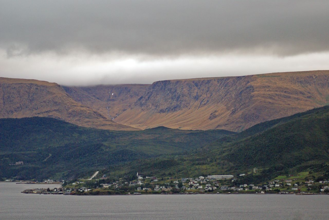
Gros Morne National Park is a wonderland for geologists and hikers alike. One of its best-known features is a range of flat-topped hills beside Route 431 just outside the town of Woody Point -- a spot known as the Tablelands. The rusty orange tone of the hills comes from the peridotite that is their main component; when it's freshly exposed, this rock is a dark grey-green, but with oxidation it takes on a mellow golden tone. This rock is part of an exposed section of the earth's mantle; further metamorphic activity turns it into a rock called serpentinite, examples of which can be widely found here.


Gros Morne's Tablelands
Earth's mantle? That's right -- this is a section of rock that was once deep below the earth's surface, formed roughly 1.2 billion years ago. The process of continental drift several hundred million years ago forced this mantle rock upward, and subsequent erosion has given the hills their present form. They remain barren because the peridotite is low in life-sustaining nutrients and contains toxic concentrations of heavy metals. What vegetation that is found here is mostly along an old roadbed, on rock that was brought in for the purpose of road building. A well-maintained trail follows this roadbed, crossing Winterhouse Brook, which flows out into Bonne Bay just outside Woody Point.

Round-leaved sundew (Drosera rotundifolia)
A walk along this trail reveals a surprising number of small, hardy plants that have developed the survival tactics necessary for such a forbidding environment. Many of them, like pitcher plants, butterwart, and the round-leafed sundew shown at left are insectivorous; instead of obtaining all their nutrients from the soil, they attract insects and through a variety of processes absorb the life-giving substances they need from the insects themselves or from their droppings. It's not an easy life, to say the least.


Winterhouse Brook
Continue along the trail as far as Winterhouse Brook (right), where snowmelt and run-off from the tops of the Tablelands form a swift-running stream. This area has a challenging winter climate, and a heavy snow load on the upper slopes often persists into late summer. If you think this place looks strange and otherworldly you're not alone. In fact, the landscape here is so forbidding that NASA has sent research teams here to investigate the area's similarity to the surface of Mars. On a beautiful summer day, though, it's a beautiful and fascinating little corner of Earth, and well worth a side trip. Woody Point is located on Newfoundland and Labrador Route 431, about 70 km from the town of Deer Lake. It has a motel, bed and breakfast accommodations and campgrounds nearby, and there are shops, restaurants and other services, and is roughly an hour away from Rocky Harbour. Parks Canada's Discovery Centre has high-quality informative displays, park information and a gift shop.

Woody Point and the Tablelands

Wednesday, March 09, 2016

Exploring Rose Blanche

Rose Blanche Lighthouse
When approaching Rose Blanche, the most striking feature on the landscape is an impressive stone lighthouse, one of a series built between 1871 and 1873 along this coast. The Rose Blanche light is one of the last surviving stone lighthouses on the Atlantic Coast of Canada, and had fallen into disrepair by the 1990s, but the stone steps inside the tower were of such robust construction that they kept the building from falling down; restoration of the building was completed in 1999.

The Harbour at Rose Blanche

The little harbour of Rose Blanche is now accessible by road, but is still well off the beaten path so it sees fewer visitors than many more accessible Newfoundland communities. My own first visit here was on a superb July morning in 2015, on a cruise with  Adventure Canada. We dropped anchor just outside the harbour and made our way to shore in Zodiacs, landing at the public wharf and hiking to the lighthouse. The old path led around the inner harbour and over the hills, where the sun warmed berry fields and small ponds along the way. After seeing the lighthouse and the well-designed interpretation area at the end of the road, there was a warm welcome for the ship's passengers at St. Michael and All Angels Anglican Church on the hill overlooking the harbour.


Lighthouse Point
Looking seaward
Rose Blanche now shares government with neighbouring Harbour Le Cou, the subject of a well-known traditional song from Newfoundland, here performed by the group Ryan's Fancy. If you're visiting by road, the community is located on Newfoundland's scenic southwest coast, about 45 minutes east of Port aux Basques via provincial Route 470.


Lighthouse interior


Take a walk through Rose Blanche via Google Street View here. Amenities include bed and breakfast accommodations, shops and cafes.

Wednesday, March 02, 2016

Life on the Rocks in Point Riche

Marine gastropod fossil
One of my favourite moments during a visit to western Newfoundland is the "life on the rocks" exploration of Point Riche. The headland lies near the town of Port-au-Choix, on the island's Great Northern Peninsula, and its white octagonal lighthouse with a bright red lantern room is a striking sight. Below the lighthouse, though, is where this spot's treasures are found. In the broad limestone beds on the shore, thousands of marine fossils, mostly cephalopods and gastropods can be seen.  It takes only a moment for the eye to become accustomed to the search; when it has, a scan of the rocks reveals one tight spiral after another, sometimes dozens within a space the size of a small notebook.

Fossils at Point Riche
Among the fossils are tidal pools that evaporate quickly in the summer sun, leaving a rim of salt around their edges. In the cracks of the rock, tiny plants take root in the most challenging of circumstances. Minke whales, seals and dolphins can occasionally be seen passing by, and when there are small fish like capelin or juvenile herring in the area, northern gannets knife into the water. There is a small herd of caribou living in the area, and a few moose can also be seen from time to time.

The limestone barrens on the Northern Peninsula are home to many varieties of calcium-loving plants, some of them found only in this environment, so it's necessary to tread carefully on the plateau above the shore. Just up the road, also part of the Port-au-Choix National Historic Site, is an interpretation centre that concentrates on the area's remarkable human history; a succession of occupations of the area by various cultures go back some 6000 years.

The nearby towns of Port au Choix and Port Saunders are centres for fishing in the area, and there are restaurants, hotels and other services nearby.


A miniature garden among the rocks


Wednesday, February 24, 2016

Coming back to Nain

Nain's brass band
There's a little community in Nunatsiavut that I've loved since the first time I visited -- it's the northernmost inhabited community in the province of Newfoundland and Labrador, and the largest community in Nunatsiavut and its administrative capital. I first visited Nain in 1994 via the M.V. Northern Ranger, as part of a cruise along the coast. In those days, the Ranger operated out of Lewisporte on Newfoundland's northeast coast, and the trip took in all the small ports along the way, including St. Anthony, Red Bay, and Cartwright on the way to Goose Bay - Happy Valley. Today the vessel still runs, but it's now operated by Nunatsiavut Marine and plies the coast only from Goose Bay northward, stopping at Rigolet, Makkovik, Postville, Hopedale, and Nain, with a stop in the Innu community of Natuashish as well.

On the roof!
My most recent visit, though, was from a different vessel: the Ocean Endeavour, operated by Adventure Canada. I was delighted to see that Nain would be one of the stops on their Newfoundland and Wild Labrador cruise in 2015, and was eager to return to the place where there were so many wonderful memories. The icing on the cake was that the stop happened to fall on my birthday, July 11.

Carver John Terriak


In the years since I'd been to Nain, a very important development had taken place: the local brass band, established by the Moravian Church as part of its outreach to the coast, had been resurrected through the efforts of a dedicated group of volunteers and advocates including Dr. Tom Gordon of Memorial University, who was a fellow staffer on the Adventure Canada team.When the Ocean Endeavour arrived, the band was there to greet us -- and after a welcome at the little white church near the public wharf, the band members followed tradition and climbed from the church tower onto the roof to play so the sound would carry better!

Pitsik
The welcome in Nain was as warm as ever, thanks to Tourism Nunatsiavut, and there was time to explore the community, see a demonstration of soapstone carving by noted carver John Terriak, taste some local delicacies like partridge soup and pitsik -- dried char -- and do a bit of shopping for soapstone, sealskin, knitted goods and other keepsakes before a reception with Inuit games at the local school; a buttery-soft sealskin eyeglass case seemed like the perfect birthday present, and by chance, the young man who sold it to me was celebrating his birthday as well -- along with his twin brother! We wished each other a happy birthday, and I was on my way.

The perfect keepsake

It was a delight to return to this little spot after an absence of nearly twenty years; I've promised myself it won't be so long before my next visit. Nain is on the itinerary of Adventure Canada's Greenland and Wild Labrador
cruise for 2016.

Leaving beautiful Nain