Showing posts with label Cape Sable Island. Show all posts

Friday, May 06, 2016

Reflecting on Nature


While sorting through a few archived images for a project, I was struck with how many of them had one striking feature in common: reflections. Whether in sea water, glass or even wet pavement, this simple phenomenon has the power to captivate. I have to admit that I'm pretty much addicted to them. Sometimes the morning sun's low angle sets off a perfect combination of elements to create an unforgettable image.
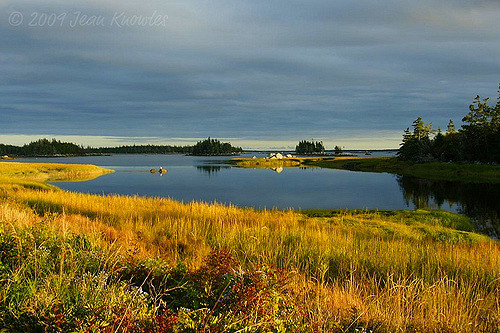


Sometimes it's the evening light that does it, turning marsh grass to gold, deepening the colours of the blue-grey clouds and painting the granite rocks a stark white, like this scene in Atwood's Brook, NS.


Blue Rocks, Nova Scotia, is a picturesque spot at any time, but the touch of the early morning sun on the golden shades of autumn can make it even more beautiful.


Evening's soft rose tones on a winter day can create a Rorschach sunset around the inshore islands. This is another scene from Atwood's Brook, NS.


A few sanderlings scouting for food at the water's edge make for some striking reflections in the wet sand of Daniel's Head Beach, Cape Sable Island, NS.

Friday, May 10, 2013

Patterns in the Sand


Beaches are wonderful places for walking, running, digging for clams, watching birds or watching surf, listening to the rhythms of nature or perhaps doing absolutely nothing. One of the things I love most about them, though, is that beaches are, in a very real sense, living things. Each visit is met with a new and changing landscape; sometimes the changes are small and insignificant, while others, like those brought on by winter storms, are sweeping and more permanent in nature: wind-driven waves rip through protective dunes and spill onto the flats beyond, or tons of sand are moved offshore leaving rocks and gravel exposed. It can take years for major changes like these to reverse themselves.


Smaller, gentler changes, though, are here reward the careful observer. The breeze plays over the surface of the sand sculpting patterns that are particularly striking in the low-angled light of morning and evening, creating miniature desert or mountain landscapes. Return the next day or even a few hours later, and those landscapes will be altered: ridges lower or higher, textures smoother or coarser, new patterns overlying the old. As the tide changes, the water works in concert with the wind to form a new array of relief figures. The movement of breeze and water shift the small particles of sand and shell, sorting them by size and weight. Waves roll in along the swash zone, compacting the surface. Farther up the beach face lies the wrack zone, where seaweed marks the high tide line. Above this is the berm, the raised area where the sand is generally dry. In summer, this zone provides a vital nesting area for shore birds like sandpipers and plovers; their camouflaged nests are vulnerable to beach walkers, so it's crucial to stay below the tide line when walking.


I seldom visit a beach without a camera, and it's not there just for the birds or the waves or the cloud reflections; these erosion patterns are simply too tempting and to varied to ignore, and I love the way they mimic flames, waves, mountains and canyons -- or sometimes even characters from a Tolkien novel.  The constantly shifting personality of the beach at the seemingly subtle whims of moving air and water means that in nature, as in life, the only real constant is change. There's nothing like a metaphor you can photograph.


Wednesday, February 20, 2013

Days of Sorrow


It's impossible to live in a small, closely-knit coastal community and not feel the effects of harrowing loss. Southwestern Nova Scotia is experiencing such sorrow, with the sudden and tragic loss of the halibut-fishing boat Miss Ally and the five young men on board.  The skipper was Katlin Nickerson of Wood's Harbour, and with him on the voyage were Joel Hopkins, Cole Nickerson, and Tyson Townsend, all of Wood's Harbour as well, and Billy Jack Hatfield from nearby Cape Sable Island.  The five set out in the 14-metre Cape Islander on February 12, 2013 to pursue the winter halibut fishery, which takes place in during the worst of winter's storms and gales. After the boat's emergency beacon was activated on Sunday night, searchers were hampered by sea conditions that included wind, freezing spray and waves of 10 metres or more. Several aircraft, two Coast Guard vessels and various merchant vessels took part in the search, but the search area was broad and the sea conditions far from ideal. The fishing communities of Southwestern Nova Scotia waited, tension thick in the air, while the search continued; nighttime brought a gesture of solidarity throughout the region as homes up and down the shore left a light on through the night to speed the men's safe return. It was all to no avail, though, as the search was called off on Tuesday evening.   In addition to other family members, the captain and crew of the Miss Ally leave behind a total of six children. Hearts are heavy along the shore today.

Monday, February 27, 2012

Cape Sable Island webcam

Check out the new webcam on the block -- showing the Cape Sable Island causeway. The name's a bit misleading, since the webcam is located in Barrington Passage, on Nova Scotia's mainland, but view is of the causeway and the island itself.

Speaking of misleading names, there's a certain tendency on the part of people not familiar with Nova Scotia's geography to confuse Cape Sable Island with Sable Island, that magical, drifting crescent of sand famous for wild ponies and breeding seals. It's understandable that the
names are so similar, since the word sable is French for "sand" and both island are notable for their dunes and beaches. To add another layer of confusion, just to the south of Cape Sable Island is another island known simply as Cape Sable, where a lighthouse warns mariners off the constantly shifting undersea sandbars.

Cape Sable Island is connected to the mainland of Nova Scotia by a causeway that's roughly three-quarters of a mile long, built of stone from a nearby quarry. The causeway was completed in 1949 and replaced a coastal ferry service that linked North East Point, on the island, with the mainland
community of Barrington Passage. The ferry had run, in one form or another, since the closing years of the 17th Century. Interestingly, one of the later ferry boats employed on the run, the Edgar N. Rhodes ended out its days plying Bonne Bay, Newfoundland, between the ports of Woody Point and Norris Point; this was the principal route to the Great Northern Peninsula prior to the construction of a road along the north side of Bonne Bay.